| March 1998 Trip: Day 4 |
 Day 4. The final leg. We were leaving Savannah, Georgia and we needed to get to Miami Beach, Florida. The plan was to continue hugging the coast a little while longer until we had a clear cross country route to Miami Beach. After an exciing breakfast at the International House of Pancakes, we headed out of lovely Savannah. All the bad weather from the previous day had blown away. There were beautiful blue skys with friendly white puffy clouds. An increadible day for driving. We started on US Route 17 through South Carolina and into Jacksonville, Florida. At this point we were finally free to head straight toward Miami Beach without worrying about hitting the ocean. As we traveled more or less straight toward Miami Beach, the coast would curve away from us before coming back in again. We switched from US routes that were not really going quite the right way to State routes that were. Then when the state routes we were on started going the wrong way, we decided to cut straight through the town of Roy, Florida on local roads in order to get to the next State route going our way.
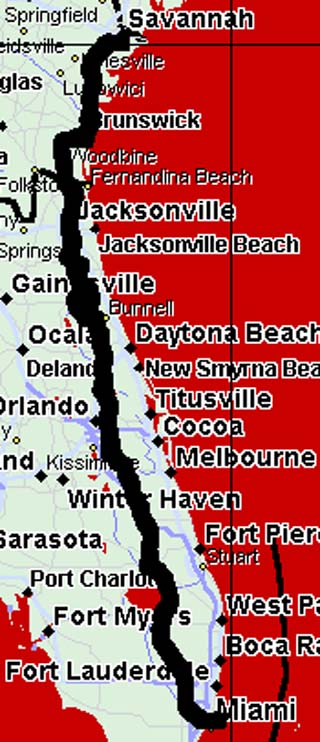
On our laptop using Delorme Street Atlas software, Roy seemed to be a pretty large town. There was a grid of streets several miles on a side. This would be a nice trip through a nice town. When we first entered we saw a few nicely layed out streets with a couple of houses. As we continued the houses gave way to trailers. The streets turned from nice pavement to dirt. The signs of electricity and phone lines stopped. But all the roads were still clearly marked with street signs so we continued. Then the dirt roads became grassy roads. Still clearly marked and named. Then the grass roads became mud roads. And the stench of the swamp surrounding us began to be very noticiable. What the map software failed to mention, is that the "town" of Roy is one of these scams where they get you to buy land in Florida. The place is a swamp. There is no town. Just a few places where they have cleared and drained bits of the swamp and layed out hat might become real roadeds. Someday there may be a town. But not this decade. Several times we almost got stuck in the mud. Ivan was very adgitated. We were still plugging onward though, because the maps showed that just ahead were several roads leading out of Roy and back toward civilization. But when after 30 minutes of slowly driving on muddy roads trying not to get stuck we arrived at the location of the exit road and discovered IT DID NOT EXIST AT ALL, we determined that there was no choice but to just turn around, go back where we came from, and try a different route. All in all, we lost over an hour of time in Roy. But it was pretty exciting. After backtracking, we found an alternate route that was actually a pretty fast US Route. On US routes and a few state routes we headed South and passed through the Eastern suburbs of Orlando. We were about 15 miles from Disney World, but this was not the trip for visiting Mickey. Our path continued South, eventually running into the Northern side of Lake Okeechobee. It is a big lake. We followed around the eastern side of the lake. When we got around the lake we swithed to US 27. US 27 was pointing almost exactly at our hotel. US 27 was very very strange. First of all it was absolutely, completely, and totally straight for about 20 miles. It was almost completely dark on all sides of the road. There was NOTHING out there. Well... actually there was... which added to the strangeness. Apperantly there is a huge network of canals throughout that entire region. Laid out in a rectangular grid pattern just like planned cities (like Roy). At many places on US 27 unmarked roads would just turn off to the left or the right heading off into the darkness. As far as we could tell from the maps, these roads just headed into nowhere... in the middle of all those canals. On a small number of those lights and buildings were visibile in the far distance. But on most the road just dissapeared into the darkness. It all seemed very very strange. We have no idea what all those canals are for, or what the roads are for. I presume they are related. After the canal area US 27, still straight as an arrow with the sparse traffic moving at 85 miles an hour or faster, headed through the Everglades swamps. We did not see alligators. We just saw darkness on all sides. Until suddenly, there was Miami. As we entered Miami Ivan started rumbling about "bad neighborhoods". Soon after we missed a turn (OK, I told Ivan to go the wrong way) and I gather from Ivan's reaction, we ended up in one of those areas he didn't like. To keep Ivan from having a heart attack we got back onto US 27 fairly quickly. It was still pointed straight at our hotel. It did have the problem that right before the road crossed over the bridge from Miami proper to Miami Beach it changed from US 27 to I-195. We considered getting off before the switch and navigating through the city to another bridge that was not an Interstate. But it was late. We had been driving for almost 12 hours. Ivan was muttering about bad neighborhoods again. And the I-195 bridge dumped us into Miami Beach only a block or two from the hotel. So we just took the bridge. After all, we had hit that bit of Interstate in Savannah anyway. And thus we arrived at the Fontainebleau Hilton in Miami Beach from Plainsboro, New Jersey. |