Finally, days after initially expected, as of the 21 UTC update from the National Hurricane Center, we are in the three day bubble for Hurricane Wilma:
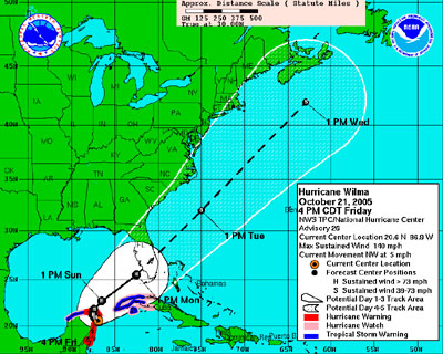
We’ve been in the five day bubble for what seems like forever, but this is the first we’ve been in the 3 day. We’ve been thinking “surely we’ll be in the three day by the next update” since Tuesday night or Wednesday morning.
Not that we like being in the bubble or anything, but it has been “coming” for like a week now. Of course, one of the reasons it is late coming here is it is absolutely pummeling the Yucatan, which looks like it will be horrible for folks living there. They are predicting for Wilma to basically sit on top of Cancun ALL WEEKEND. And it already has been having major effects most of the day Friday. That will not be good.
Anyway, I’ve found two new charts at the NHC that I like a lot better and tell more I think. They were there for the last few hurricanes too I think, I just didn’t pay any attention. These reflect the actual odds of given places getting certain amounts of winds.
So for instance, in this one covering from now until 18 UTC on Wednesday you can see what the chances are of hurricane force winds in that time frame at different places:
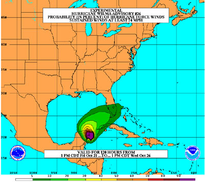
So looking at our approximate location, and doing a little eyeball interpolation, the chances of us getting hurricane force winds here in Palm Bay are about 5%. So not zero, but not all that high either.
For tropical storm force winds, our odds are a bit higher:
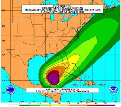
For our location I guestimate about a 35% chance of tropical storm force winds.
Of course, the way odds go, as the time of the event approaches, it either moves to 0% or moves to 100% since quantum effects aside, it will either happen or not.
But the long and short of it is that we will probably (65% chance) get absolutely nothing of note. But there is a decent chance of getting some tropical storm force winds. And even the 1 out of 20 chance of hurricane force winds is nothing to sneeze at. It could happen.
So we’ll of course be watching carefully the next few days.
I’d like to point out that we are almost exactly on the centerline of the new official projected path. This is one of the reason I like the ones based on probability a lot better. It better reflects the total uncertainy about the path and what may happen. The fact that we are right on the center line is concerning, but really not of much more concern than if we were anywhere else in the bubble. There is enough of a chance of trouble to pay close attention, and make basic preparations, but not for panic.
Like they keep saying on TV, don’t just pay attention to the centerline. Look at the whole bubble.
We postponed Amy’s birthday party from this weekend to next weekend because a couple days ago when we had to make the call it was more like a 60% chance of TS winds and a 30% chance of hurricane winds, and right on Saturday to Sunday when the party/sleepover would be. We had to make the call in enough time to let all the invitees plan accordingly. But still… now Amy is all disappointed by the delay in her party and it will probably be a beautiful day tomorrow. Sigh!
But we did let her open her big present though. As I am writing this she has the new kareoke machine cranked up and is singing “Mony Mony”. So I guess that is all OK. :-)